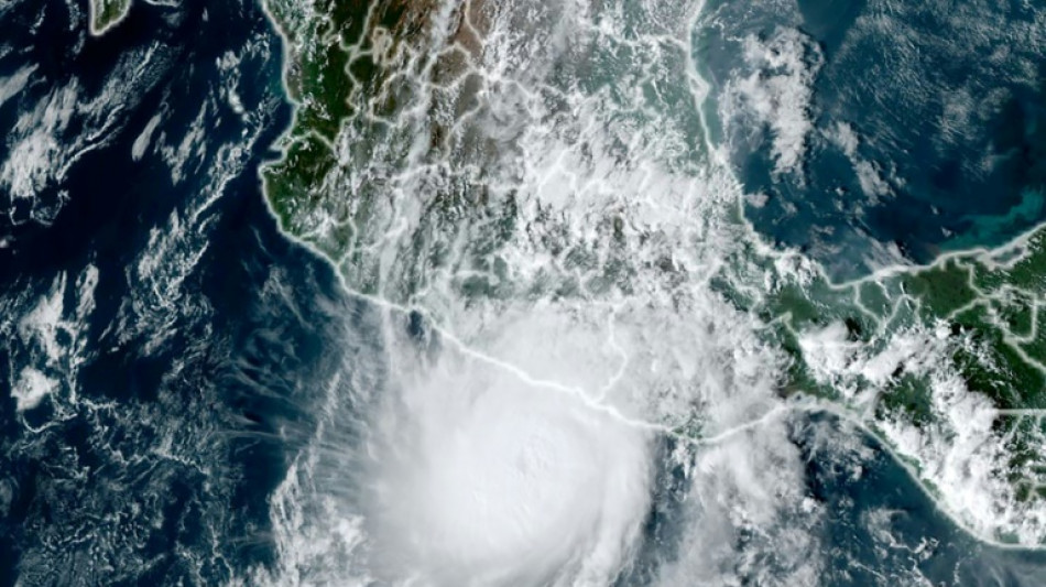
Why did Hurricane Otis 'explosively' intensify off Mexico? / Photo: © NOAA/AFP
 Canada star Kone to miss rest of World Cup after surgery: team

 Confident Fitzpatrick makes a run at another US Open title

 England captain Stokes strikes for Durham as Test recall looms

 Clark wants to win back fans as well as US Open title

 Clark leads as fellow major winners charge at US Open

 Ton-up Nicholls turns the screw for New Zealand against England

 Sun shines on jockey Lee at Royal Ascot

 Oil edges back up, shares steady after US-Iran talks postponed

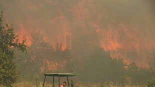
 Europe swelters as more heat records set to tumble

 'There's no soul': Tony Leung weighs in on AI in filmmaking

 From Versailles to a Swiss mountain: a week of dizzying Iran diplomacy

 Coach tells S. Korea to move on fast with World Cup knockouts in reach

 Henry strikes as New Zealand strengthen grip against England

 England captain Stokes in action for Durham as Test recall looms

 Moutet fined over x-rated Queen's Club rant

 Outrage in Italy after Trump says Meloni 'begged' for photo op

 From birds to fish, how extreme heat causes wildlife to suffer
 Trapped on Everest for days, Nepali survivor recounts escape

 Clark leads by three as US Open second round begins
 Fritz gets revenge on Shelton to reach Halle semis

 Heatwave hits more than half of France's population

 Former England keeper Earps agrees to join London City Lionesses

 Olympic hurdles medallist Bascou suspended for doping

 Pegula sinks Keys to reach Berlin Open semis

 Gaza ceasefire a 'deadly illusion': UNICEF

Hurricane Otis caused at least 27 deaths and major damage as it battered Mexico's beachside city of Acapulco as a scale-topping category 5 storm, according to officials.
The speed with which Otis rapidly intensified took the government and weather forecasters by surprise, leaving little time to issue warnings and prepare for its arrival.
Why was Otis so devastating?
"Otis's intensification was very exceptional. It was nearly record-breaking in some ways," said Michael Brennan, director of the Miami-based National Hurricane Center (NHC).
Within hours Otis strengthened from a tropical storm to the most powerful category of the five-step Saffir-Simpson scale before hitting land early Wednesday.
Otis "explosively intensified" with peak wind speeds increasing by 115 miles per hour over a 24-hour period, according to the NHC, which issues storm warnings and forecasts.
Otis was packing maximum sustained winds of 165 miles (265 kilometers) per hour when it hit the coast, the NHC said.
The World Meteorological Organization described the hurricane as "one of the most rapidly intensifying tropical cyclones on record," only exceeded in modern times by Hurricane Patricia in 2015.
Why did Otis intensify so quickly?
"Unfortunately Otis was able to take advantage of very favorable conditions" including warm deep ocean water and a conducive atmospheric environment, Brennan said.
"The storm was able to develop an inner core and a structure that allowed it to take advantage of those favorable conditions and environment in the ocean and the atmosphere to rapidly intensify," he said.
While hurricanes hit Mexico every year on both its Pacific and Atlantic coasts, usually between May and November, few make landfall as a Category 5.
"There are no hurricanes on record even close to this intensity for this part of Mexico," the NHC had said as Otis approached the Mexican coast, warning that a "nightmare scenario" was unfolding.
Is climate change to blame?
The water temperatures off the Mexican coast that Otis encountered were 30 to 31 degrees Celsius (86-88 degrees Fahrenheit), Brennan said.
"That may be a little bit warmer than usually but not tremendously so. That area is usually quite warm and has quite deep warm ocean water this time of year," he added.
"So it's hard to necessarily attribute that particular aspect of this to climate change or global warming. We'll have to look back and do some studies," Brennan said.
Will global warming bring more devastating storms like Otis?
Brennan said that "the science on that is not terribly well resolved at this point."
"There are some studies that suggest that rapid intensification is becoming more common in a warming climate," he said.
"We are very confident that the impacts of hurricanes from heavy rainfall, flooding and storm surge are worsening in a warming climate and will continue to worsen as the climate warms," he added.
That was due to rising sea levels leading to more dangerous storm surges and a warmer atmosphere holding more moisture, resulting in heavier rainfall, Brennan said.
The UN's Intergovernmental Panel on Climate Change said in 2021 that the proportion of particularly intense cyclones (categories 4 and 5) should increase by 10 percent compared to the pre-industrial era with a warming of +1.5 degrees Celsius, by 13 percent at +2C and by 30 percent at +4C.
As a result of sea-level rise and marine flooding, more than one billion people will live in coastal cities at risk by 2050, according to the IPCC.
F.Mueller--VB