Slew of satellite projects aims to head off future wildfires / Photo: © AFP/File
 Caudullo challenges Montpellier to be 'watertight' against Dupont threat

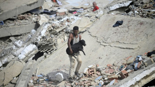
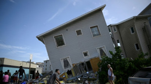
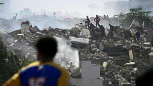
 Venezuela earthquakes toll soars to 589 amid desperate rescue effort

 Stokes strikes on England return before Duckett runs riot against New Zealand

 UK hottest June day record broken for third day in a row: Met Office
 Tech jitters send stocks lower, oil prices fall

 Stokes strikes on England return as New Zealand all out for 438

 Caudullo challenges Montpellier to be 'watertight' against Dupont

 Osaka sinks Wang to reach first grass court final

 UN demands probes into US ICE custody deaths

 Stokes strikes as New Zealand make England feel the heat

 Lyles enjoying freedom to focus on speed and stuff off the track

 How the British royal family is funded, and where the money goes
 Russia-annexed Crimea declares 'emergency' amid Ukraine strikes
 Stocks slide on renewed tech slump, oil prices fall
 EU hits France's Sanofi with flu vaccine antitrust probe

 Europe heatwave swamps hospitals, halts parties

 MEXC Reports 142% Volume Surge for MU Futures Following Record Micron Earnings Beat

 Serena Williams to face Joint in Wimbledon return after four-year absence

 UN says Iran nuclear pledge needs 'very strong' verification
 New Zealand internal report warns of Chinese military forays in Pacific
 Mbappe v Haaland as France face Norway in World Cup group decider

 European economies suffer from heatwave

 Hospitals overwhelmed as Europe heatwave shifts east

 努莎·奧貝爾與迪特馬爾·沃伊德克 波茨坦如何辜負一名重度殘障幼兒
 'Very strong' nuclear verification needed in Iran after war: IAEA head

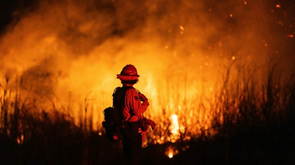
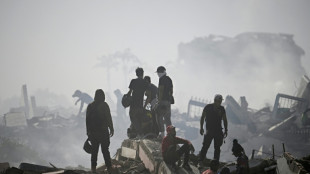
As Los Angeles firefighters battle remaining hotspots more than a week into deadly blazes, scientists and engineers hope growing availability of satellite data will help in the future.
Tech-focused groups are launching new orbiters as space launches get cheaper, while machine learning techniques will sift the torrent of information, fitting it into a wider picture of fire risk in a changing environment.
Satellites "can detect from space areas that are dry and prone to wildfire outbreaks.... actively flaming and smouldering fires, as well as burnt areas and smoke and trace gas emissions. We can learn from all these types of elements," said Clement Albergel, head of actionable climate information at the European Space Agency.
Different satellites have different roles depending on their orbit and sensor payload.
Low Earth orbit (LEO) is generally less than 1,000 kilometres (620 miles) above the surface -- compared with up to 14 km for an airliner.
Satellites here offer high-resolution ground images, but see any given point only briefly as they sweep around the planet.
Geostationary satellites orbit at around 36,000 km, remaining over the same area on the Earth's surface -- allowing for continuous observation but usually at much lower resolution.
As climate change brings growing numbers of wildfires encroaching on human-inhabited areas, that resolution can be crucial.
In Los Angeles, "there are satellite observations, but it's very hard to determine -- is it my house that's on fire? Where exactly is this?," said WKID Solutions' Natasha Stavros, a wildfire expert who has also worked at NASA.
"Some people stay because they don't really understand... that's where this idea (that) we need more observations available comes from."
- 'More fire than we know' -
Brian Collins, director of Colorado-based nonprofit Earth Fire Alliance, plans a new low-orbit satellite "constellation" to complement existing resources.
It will sport a sensor with a resolution of five metres (16 feet), much finer than ESA's current Sentinel-2 satellites that can see objects only 10 metres wide.
This means "we're going to learn very quickly that there is more fire on the Earth than we know about today, we're going to find very small fires," Collins predicted.
EFA aims to launch four satellites by the end of 2026, the first in just a few weeks, at a total cost of $53 million.
That figure is a "drop in the bucket" against the property damage and lives lost to wildfires, said Genevieve Biggs of the Gordon and Betty Moore Foundation, which has financially supported EFA's satellite project.
It would take the whole planned swarm of 55, costing a total $400 million, to reach Collins' aim of imaging every point on Earth at least once every 20 minutes.
Dozens of satellites in orbit could "both detect and track fires... at a cadence that allows decisions to be made on the ground," Collins said.
Less grandiose efforts include Germany-based OroraTech, which on Tuesday launched the first of at least 14 shoebox-sized FOREST-3 "nanosatellites".
The system will "deliver ultra-fast wildfire alerts and high-quality thermal data," chief executive Martin Langer said in a statement.
The Moore foundation is also backing a geostationary satellite project dubbed FUEGO.
- 'Last mile' -
Additional data from all these new satellites would be "fantastic", ESA's Albergel said, but the large volume of information can prove problematic.
ESA's Sentinel-2 alone sends down one terabyte of data -- the storage capacity of a modern high-end laptop -- every single day.
Finding fire signs in such reams of data "is an excellent machine learning, artificial intelligence problem... the 'needle in the haystack'," Collins said.
The data could ultimately help both predict new fire outbreaks and their progression, he added.
Looking ahead, Stavros said there was no "silver bullet" technology for wildfires.
"It's all of them working together" that will help emergency responders and slash risk from fire, Stavros said.
Beyond high-tech detection and tracking, the Moore Foundation's wildfire programme also focuses on making communities more resilient and managing fire-prone ecosystems -- which can include "increasing ecologically beneficial fire while decreasing detrimental fire", Briggs said.
C.Bruderer--VB